Bühlertal
You can help expand this article with text translated from the corresponding article in German. (February 2009) Click [show] for important translation instructions.
- View a machine-translated version of the German article.
- Machine translation, like DeepL or Google Translate, is a useful starting point for translations, but translators must revise errors as necessary and confirm that the translation is accurate, rather than simply copy-pasting machine-translated text into the English Wikipedia.
- Do not translate text that appears unreliable or low-quality. If possible, verify the text with references provided in the foreign-language article.
- You must provide copyright attribution in the edit summary accompanying your translation by providing an interlanguage link to the source of your translation. A model attribution edit summary is
Content in this edit is translated from the existing German Wikipedia article at [[:de:Bühlertal]]; see its history for attribution. - You may also add the template
{{Translated|de|Bühlertal}}to the talk page. - For more guidance, see Wikipedia:Translation.
Municipality in Baden-Württemberg, Germany

Coat of arms
Location of Bühlertal within Rastatt district

(2016–24) Hans-Peter Braun[1]
(2022-12-31)[2]
77830
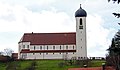
Bühlertal is a municipality in the district of Rastatt in Baden-Württemberg in Germany.
Geography
Geographic location
Bühlertal encompasses almost the entirety of the Bühlot Valley and its side valleys on the Western slope of the Northern Black Forest at the ridge to the Upper Rhine Valley from an elevation of 190 meters to 1000 meters above sea level.
Municipality
To the municipality of Buehlertal belong the Obertal (Upper Valley), the settlements Altenberg, Denni (now fused with the Obertal), Boosweg (joined with Obertal), Laengenberg, the hamlets Buchkopf, Buechelbach (joined with Butschenberg), Laube (bridging Untertal and Obertal), Liehenbach (fused with Untertal), Schafhof, Schoenbuech (joined with Obertal and Buchkopf), Schwarzwasen, Sessgass, Steckenhalt, Untertal, Wintereck and Wolfsbrunnen, the hamlets Eichwald, Freihoefen, Haaberg, Hatzenwoerth, Hirschbach, Hof, Hungerberg, Klotzberg, Lachmatt, Matthaeuser, Schmelz und Sickenwald, the farmsteads Butschenberg und Gertelbach, Grasiweg, Holzmatt, Immenstein, Kohlbergwiese, Mittelberg, Oberer Plaettig (Upper Plaettig), Wiedenfelsen und Wolfshuegel. The hamlet Mistgraben is defunct since 1492, but was mentioned in two baptism records around 1860 as a location.
History
Oldest records about Buehlertal are from 1301. It belonged to the County of Eberstein. The Margraviate of Baden owned farms in Buehlertal since 1536. In 1688, the ownership of Bühlertal was transferred between the Earl of Eberstein and the Margrave of Baden. It belonged to the county of Bühl, which became the Landkreis Bühl. When the county (Landkreis) of Bühl was dissolved in 1973, Bühlertal became part of the county of Rastatt (Landkreis Rastatt).
External links
- Official website of Buehlertal
- Buehlertal on leo-bw.de
- Museum Geiserschmiede
- Buehlertal Family Book
- Bühlertal
-

-
-
-

-
-

-

-


References
Wikimedia Commons has media related to Bühlertal.
- ^ Aktuelle Wahlergebnisse, Staatsanzeiger, accessed 14 September 2021.
- ^ "Bevölkerung nach Nationalität und Geschlecht am 31. Dezember 2022" [Population by nationality and sex as of December 31, 2022] (CSV) (in German). Statistisches Landesamt Baden-Württemberg. June 2023.
- v
- t
- e
Towns and municipalities in Rastatt (district)
- Au am Rhein
- Bietigheim
- Bischweier
- Bühl
- Bühlertal
- Durmersheim
- Elchesheim-Illingen
- Forbach
- Gaggenau
- Gernsbach
- Hügelsheim
- Iffezheim
- Kuppenheim
- Lichtenau
- Loffenau
- Muggensturm
- Ötigheim
- Ottersweier
- Rastatt
- Rheinmünster
- Sinzheim
- Steinmauern
- Weisenbach

Authority control databases | |
|---|---|
| International |
|
| National |
|
 | This Rastatt district location article is a stub. You can help Wikipedia by expanding it. |
- v
- t
- e


