History of Surat
City in India
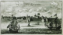
Surat was founded in the late medieval period, and gradually became an important port in the Mughal Empire, though the earliest human presence may go as early as 300 BCE.[1][2] The Maratha rulers defeated the Mughals during the Battle of Surat. Later, the Dutch ruled the area and the city became known as Dutch Suratte.
Medieval history
In the 12th and 15th centuries, Surat was plundered by Muslims.[3] In 1512, and again in 1530, Surat was ravaged by the Portuguese Empire. In 1514, the Portuguese traveler Duarte Barbosa described Surat as an important seaport, frequented by many ships from Malabar.[4]
Gujarat Sultanate
Several early European travellers to India make mentions about an influential Brahmin named Malik Gopi, who settled the region and founded the city.[5] It is possible that Gopi was a governor under the Gujarat Sultanate.[6] Notably, Gopi oversaw the construction of an artificial lake, known as Gopi Talav, for water storage in 1516. The area he developed was called Gopipura in his honour. For his contributions, Gopi was given the title Malik by the Sultan of Gujarat Muzaffar Shah II.[7] The town that Gopi developed was unnamed for long and after consulting astrologers he proposed to name it "Suraj" or "Suryapur". By 1520, the name of the city had become Surat[3] as the king, disliking the Hindu inclination of the name, altered it to "Surat", (alluding to the Arabic words for headings of the chapters of the Quran).[8] Gopi also finds mentions in Portuguese literature as "Lord of Surat and Bharuch".[7]
Mughal Empire
In 1573, Surat was conquered by the Mughals.[3] It was the most prosperous port in the Mughal empire, used for travel to the Hajj pilgrimage.[9] Despite being a rich city, Surat looked like a typical "grubby" trader's town with mud-and-bamboo tenements and crooked streets, although along the riverfront there were a few mansions and warehouses belonging to local merchant princes and the establishments of Turkish, Armenian, English, French and Dutch traders. There were also hospitals for cows, horses, flies and insects run by religious Jains, which puzzled travelers.[9] Some streets were narrow while others were of sufficient width. In the evening, especially near the Bazaar (marketplace), the streets became crowded with people and merchants (including Banyan merchants) selling their goods. Surat was a populous city during the Mughal era but also had a large transient population: during the monsoon season, when ships could come and go from the ports without danger, the city's population would swell.[9] In 1612, England established its first Indian trading factory in Surat.[3] The city was conquered twice by the Maratha king Shivaji, with the first sacking occurring in 1664.[3][10]
Maratha Empire
Surat was sacked by Marathas twice:[11] first in January 1664 and then in October 1670.[12]
Colonial period
During the Quit India Movement of Mahatma Gandhi in 1942, A large number of 3,000 Koli cultivators from Matwad, Karadi, Machhad and Kothmadi in Surat District fought against British soldiers at Matwad with lathis and dharias on 21 August 1942. In this fight, four persons including one policeman died. The kolis also snatched away four police muskets and two bayonets. Kolis smashed up the Jalalpore Railway Station, removed the Rails and burnt down the post office. After this, situation in the neighbouring villages of Borsad, Anand and Thasra taluqas became so aggravated that British troops was marched through the villages between 22 and 24 August 1942.[13][14]
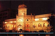
During the colonial period, Surat became the emporium of India, exporting gold and cloth. Its major industries were shipbuilding and textile manufacture.[3] The coast of the Tapti River, from Athwalines to Dumas, was specially meant for shipbuilders, who were usually Rassis.[10] The city continued to be prosperous until the rise of Bombay (present-day Mumbai). Afterwards, Surat's shipbuilding industry declined and Surat itself gradually declined throughout the 18th century.[3][10] Between 1790 and 1791, an epidemic killed 100,000 Gujaratis in Surat.[15] The British and Dutch both claimed control of the city, but in 1800, the British took control of Surat.[3][10] The Andrews Library was built during this period.
In the great fire of 1837, more than 500 people died and caused the destruction of 9737 houses. It was the most destructive fire in the history of city.[16]
By the middle of the 19th century, Surat had become a stagnant city with about 80,000 inhabitants. When India's railways opened, the city started becoming prosperous again. Silks, cottons, brocades, and objects of gold and silver from Surat became famous and the ancient art of manufacturing fine muslin was revived.[3]
Post-independence
After Indian independence in 1947, several educational institutions were founded including the NIT Surat and Veer Narmad South Gujarat University.
See also
References
- ^ "Surat" . New International Encyclopedia. Vol. XVIII. 1905. p. 714.
- ^ Malabari, Behramji (1882). Gujarat and the Gujaratis. pp. 11–37.
- ^ a b c d e f g h i "Surat". Encyclopædia Britannica. Encyclopædia Britannica, inc. 6 August 2014. Archived from the original on 10 January 2018. Retrieved 9 January 2018.
- ^ Dames Mansel Longworth (1918). Book Of Duarte Barbosa. pp. 148–149.
- ^ Barros, João de (1778). Da Asia de João de Barros e de Diogo de Couto. Brandeis University Libraries. Lisboa : Na Regia officina typografica.
- ^ Della Valle, Pietro; Havers, G. (George); Grey, Edward (1892). The travels of Pietro della Valle in India : from the old English translation of 1664. University of North Carolina at Chapel Hill University Library. London : Printed for the Hakluyt Society. p. 34.
- ^ a b M. S. Commissariat (1996). Mandelslo's Travels In Western India. Asian Educational Services. p. 11. ISBN 9788120607149.
- ^ Gazetteer of the Bombay Presidency, Volume 2. Government Central Press. 1877. p. 70.
- ^ a b c Abraham Eraly (2007). The Mughal World: Life in India's Last Golden Age. Penguin Books India. pp. 13–14. ISBN 978-0143102625.
- ^ a b c d "History of Surat". Archived from the original on 5 January 2012.
- ^ Varadarajan, Lotika Tr (1981). India In The 17th Century Vol. 1, Part. 1.
- ^ SARKAR, JADUNATH (1916). HISTORY OF AURANGZIB VOL. 3. M. C. SARKAR AND SONS LTD. KOLKATA.
- ^ Krishan, Shri (7 April 2005). Political Mobilization and Identity in Western India, 1934-47. New Delhi, India: SAGE Publications India. p. 226. ISBN 978-81-321-0208-3.
- ^ Hardiman, David (2007). Histories for the Subordinated. New Delhi, India: Seagull Books. p. 157. ISBN 978-1-905422-38-8.
- ^ Ghulam A. Nadri (2009). Eighteenth-Century Gujarat: The Dynamics of Its Political Economy, 1750–1800. BRILL. p. 193. ISBN 978-9004172029. Archived from the original on 14 October 2017. Retrieved 14 October 2017.
- ^ Gujarat State Gazetteers: Surat District (2nd (Revised in 1962), 1st (1877) ed.). Ahmedabad: Directorate of Government Printing, Stationery and Publications, Gujarat State. 1962. pp. 976–978.
| ||||||||||||||||||||||||||||||||||||||||||||||||||||||||||||||||||||||||
|---|---|---|---|---|---|---|---|---|---|---|---|---|---|---|---|---|---|---|---|---|---|---|---|---|---|---|---|---|---|---|---|---|---|---|---|---|---|---|---|---|---|---|---|---|---|---|---|---|---|---|---|---|---|---|---|---|---|---|---|---|---|---|---|---|---|---|---|---|---|---|---|---|
|  | |||||||||||||||||||||||||||||||||||||||||||||||||||||||||||||||||||||||
|
| ||||||||||||||||||||||||||||||||||||||||||||||||||||||||||||||||||||||||
| ||||||||||||||||||||||||||||||||||||||||||||||||||||||||||||||||||||||||
| ||||||||||||||||||||||||||||||||||||||||||||||||||||||||||||||||||||||||
| ||||||||||||||||||||||||||||||||||||||||||||||||||||||||||||||||||||||||
| ||||||||||||||||||||||||||||||||||||||||||||||||||||||||||||||||||||||||


