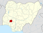
Ilejemeje
LGA in Ekiti State, Nigeria
7°57′30″N 5°14′14″E / 7.9583°N 5.2372°E / 7.9583; 5.2372 Nigeria
Ilejemeje is a Local Government Area of Ekiti State, Nigeria, consisting of seven towns. Its headquarters are in the town of Eda Oniyo.
It has an area of 95 km2, and had a population of 43,530 at the 2006 census. Its postal code is 372.[1]
Geography
Ilejemeje LGA has a total size of 95 square kilometers with an average temperature of 28 °C. The LGA's average wind speed is 10 km/h, while the area's average humidity is 63%.
Geographical coordinates are 7.958367 and 5.23734.[2]
Economy
With a variety of crops farmed in the Ilejemeje LGA, including pepper, coconut, cassava, and cocoa, farming is a significant economic activity for the locals. With various marketplaces in the LGA where a diverse range of goods are bought and sold, trade is also thriving there. Pottery, hunting, and wood carving are among of the other significant economic pursuits of the residents of Ilejemeje LGA.[3]
References
 | This Ekiti State, Nigeria location article is a stub. You can help Wikipedia by expanding it. |
- v
- t
- e


