Iruma River
River in Japan
| Iruma River | |
|---|---|
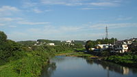 Iruma River in Hannō, Saitama | |
| Native name | 入間川 (Japanese) |
| Location | |
| Country | Japan |
| Physical characteristics | |
| Source | |
| • location | Mount Hannō in Hannō, Saitama |
| • elevation | 1,197 m (3,927 ft) |
| Mouth | |
• location | Arakawa River |
| Length | 63 km (39 mi) |
| Basin size | 721 km2 (278 sq mi) |
The Iruma River (入間川, Iruma-gawa), is a river in Saitama Prefecture, Japan.[1][2] It is 63 kilometres (39 mi) long and has a watershed of 721 square kilometres (278 sq mi). The river rises from Mount Ōmochi in Hannō, Saitama and flows to the Arakawa River at Kawagoe, Saitama.
References
External links
35°54′35″N 139°32′43″E / 35.90982°N 139.545139°E / 35.90982; 139.545139
- v
- t
- e

Rivers of Hokkaido | |||||||||
|---|---|---|---|---|---|---|---|---|---|
| |||||||||
Rivers of Honshu | |
|---|---|
Rivers of Shikoku | |||
|---|---|---|---|
|
Rivers of Kyushu | |||||
|---|---|---|---|---|---|
| |||||
 Rivers of Japan Category
 Rivers of Japan on Commons

 | This Saitama Prefecture location article is a stub. You can help Wikipedia by expanding it. |
- v
- t
- e
 | This article related to a river in Japan is a stub. You can help Wikipedia by expanding it. |
- v
- t
- e


