The January 2018 North American blizzard caused widespread severe disruption and blizzard conditions across much of the East Coasts of the United States and Canada in early January 2018. The storm dropped up to 2 feet (24 in; 61 cm) of snow in the Mid-Atlantic states, New England, and Atlantic Canada, while areas as far south as southern Georgia and far northern Florida had brief wintry precipitation, with 0.1 inches of snow measured officially in Tallahassee, Florida. The storm originated on January 3 as an area of low pressure off the coast of the Southeast. Moving swiftly to the northeast, the storm explosively deepened while moving parallel to the Eastern Seaboard, causing significant snowfall accumulations. The storm received various unofficial names, such as Winter Storm Grayson, Blizzard of 2018 and Storm Brody. The storm was also dubbed a "historic bomb cyclone".[3]
On January 3, blizzard warnings were issued for a large swath of the coast, ranging from Norfolk, Virginia all the way up to Maine. Several states, including North Carolina, New Jersey, New York, and Massachusetts declared states of emergency due to the powerful storm. Hundreds of flights were canceled ahead of the blizzard. Overall, 22 people were confirmed to have been killed due to the storm, and at least 300,000 residents in the United States lost power in total.
Early on January 1, the Weather Prediction Center (WPC) began to anticipate the possibility of a northward-tracking area of low pressure that would bring wintry precipitation to much of the East Coast of the United States in the first week of January,[4] exacerbating an extended period of anomalously cold weather.[5] Due to modeling confining of precipitation to relatively narrow bands at the time, initial forecasts on the storm's impacts were uncertain.[4] The storm's development was forecast to originate from the eastward progression of a shortwave trough originating from the northern Rocky Mountains,[6] strengthening due to the presence of a longwave trough situated over the Eastern United States.[7] However, as the anticipated event drew closer, the system's genesis grew increasingly complex with the development of two separate disturbances in the jet stream over the upper Mississippi Valley and the eastern extent of the Rocky Mountains; these two would shape the eventual coverage of wintry precipitation associated with the storm.[5] As the troughs pushed eastward, frontogenesis along the trough and a resulting increase in moisture allowed for freezing rain to commence over areas of northern Florida and southern Georgia early on January 3.[8] Later that day, rapid cyclogenesis led to the formation of a 995 millibar low-pressure area north of the Bahamas and east of Jacksonville, Florida,[9] with cloud cover quickly expanding to the north and east ahead of the storm's center; consequently, the WPC began issuing regular storm summaries at 21:00 UTC (4:00 p.m. EST) on January 3.[10]
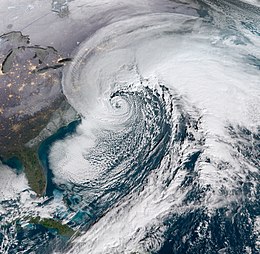
After forming, the extratropical cyclone continued to explosively deepen, tracking northward parallel to the United States East Coast.[11] By the morning of January 4, the powerful storm system had deepened by 53 mbar (hPa; 1.57 inHg) in 21 hours—one of the fastest rates ever observed in the Western Atlantic[12]—to a pressure of 952 mbar (952 hPa; 28.1 inHg), with a coastal cold front focusing heavy snowfall and thundersnow along immediate coastal regions.[13] The drop in pressure was over twice the threshold (24 mbar (24 hPa; 0.71 inHg) in 24 hours) for bombogenesis.[14] Onshore, the inland extent of wintry precipitation gradually increased as the storm intensified.[15] As the day progressed, the development of several intense snowbands allowed for heavy snowfall rates of up to 3 in (7.6 cm) per hour over New England,[16][17] which were enhanced further by the influx of warm low-level air due to the cyclone's circulation.[18] The storm bottomed out at a pressure of 950 mbar (950 hPa; 28 inHg) when it was centered about 120 mi (190 km) southeast of Nantucket Island,[19] with an eye-like feature evident. The cyclone's intensity held steady as it moved north into the Bay of Fundy late on January 4.[1] As the storm moved out of New England and began to weaken, the winds and snow began to diminish.[20] Afterwards, it opened up into a trough on January 6.
Preparations and impact
All weather alerts issued by the NWS from January 2–5 in the Eastern U.S. during the winter storm
The blizzard produced snowfall and other forms of frozen precipitation across much of the United States Eastern Seaboard. As of the WPC's fifth winter storm summary, the highest official snowfall amount recorded is 17.0 in (43 cm) in Cape May Court House, New Jersey; however, a snowfall total of 52 cm (20 in) was reported Bathurst, New Brunswick. Freezing rain totals peaked at 0.5 in (1.3 cm) in Brunswick, Georgia and near Folkston, Georgia.[19] At least twenty-two fatalities were attributed to the storm, including at least eight car accident-related deaths. At least 4,020 flights were cancelled across the United States, with a majority of cancellations caused by the extensive winter storm.[21] Insurers estimate that claims relating to coastal flooding from the storm will be more than those from snow-related damage.[22]
The Empire State Building barely visible from the 12th floor of an office building 2 blocks north during the peak of the storm due to near whiteout conditions.
Governor of VirginiaTerry McAuliffe declared a state of emergency in the state on January 3.[43] In Virginia Beach, the storm maintained gusts of 50–55 mph (80–89 km/h) for several hours.[12] In one 24-hour period, 118 crashes occurred in the Hampton Roads area, with another 121 disabled vehicles reported.[44] Across the entirety of the state, Virginia troopers responded to 245 vehicular collisions.[45] Gusts in the Hampton Roads area peaked at 69 mph (111 km/h) in Tangier, with lesser gusts farther inland.[46] Due to the local geography, water levels in Chesapeake Bay fell in response to the storm's circulation passing to the east; the Patapsco River near Fort McHenry fell 3.49 ft (1.06 m) below the mean low water level, reaching its lowest height since 1989.[47] The United States Coast Guard restricted maritime access to the Port of Baltimore from the evening of January 3 into January 5.[48]
Waves breaking in Jeddore Harbour during the storm on January 5.
New Jersey
In New Jersey, many school closures took places ahead of the blizzard on January 3, especially towards the coastal areas of the state, due to expected snow totals of 6–12 inches (15–30 cm) and gusty winds being predicted.[52] Up to 3,000 flights in the state were cancelled, with Newark Liberty International Airport registering 817 such cancellations. Due to the storm, United Airlines waived airline fees for people wanting to reschedule their flights as a result.[53] Governor Chris Christie later declared a state of emergency for Monmouth, Ocean and Cape May counties on January 4 as the storm worsened, and said all state offices would be closed, in addition to deploying hundreds of snow removal equipment to the hardest-hit counties.[54] The state police reported dozens of crashes throughout the day and dozens of residential aid requests as well. As much as 18 inches (46 cm) of snow fell in parts of New Jersey, with the largest totals closer to the coastline.[55] Strong gusty winds also impacted the state.
New England
The developing nor'easter east of Florida on January 3
Being the most geographically proximate to the storm's track, Massachusetts bore the highest impacts of all American states. Winds gusted to hurricane-force at 76 miles per hour (122 km/h) on Nantucket and over 70 mph (110 km/h) on mainland Massachusetts.[56]
In Connecticut, the National Weather Service office in Bridgeport recorded 9.0 inches (23 cm) of snow and wind gusts to 52 miles per hour (84 km/h).
At least 17.0 inches (43 cm) of snow fell on the Boston area, and 14.1 inches (36 cm) fell in Providence, Rhode Island. In Boston, a storm tide of 15.16 ft (4.62 m) was recorded during the blizzard which flooded areas of the financial district, including a subway station.[57][58] This beat the previous record set in 1978 by the Blizzard of 1978.[57] Significant coastal flooding occurred in Maine and New Hampshire.[12]
From New England the storm moved on to Atlantic Canada on January 4 and 5. Heavy snow fell in New Brunswick, peaking at 60 centimeters (24 in) in Bathurst. Sydney reported snowfall rates of up to 8 cm (3.1 in) per hour, in heavy bands of thundersnow. While snowfall amounts closer to the Atlantic coast of Nova Scotia were very low, winds gusting up to 203 km/h (126 mph) were reported in Saint-Joseph-du-Moine, causing widespread power outages. At the peak of the storm, nearly 130,000 Nova Scotia Power customers were left without power, while in New Brunswick, around 19,000 NB Power customers were left without power.[60] The storm also resulted in Confederation Bridge shutting down, as wind gusts reached 139 km/h (86 mph).[61] Offshore waves reached heights of 16 m (52 ft).[60]
Bermuda
On 5 January 2018, the storm was also responsible for a persistent thunderstorm that brought 1.84 inches (47 mm) of rain and gale-force winds to the island of Bermuda. There were wind gusts of up to 52 miles per hour (84 km/h; 45 kn).[62]
Cruise ships
On 4 January 2018, both the Norwegian Breakaway and the Norwegian Gem traveled through the storm causing major flooding in passenger staterooms. The Breakaway, with 4,000 passengers, was sailing from the Bahamas back to New York City when it sustained flooding throughout the passenger cabins as well as elevators and the hallways. Some rooms were so badly flooded that some passengers slept in the public spaces. Footage of the ordeal showed the sides of the ship being hit by waves as high as 30 feet (9.1 m). At some points in the trip, the ship tilted so much that some passengers fell out of their beds. There was widespread damage to the interior as glasses fell out of shelves and some furniture toppled over. Paintings in the art gallery could be seen falling off the walls as the ship tilted due to the turbulent seas. Seasickness was widespread as guests could be seen vomiting. While Norwegian Cruise Line released a formal apology, the incident has sparked outrage with some guests were traumatized to the point of refusing to cruise again while others threatened a class action lawsuit. The ship's late arrival cut the following 14-day cruise short by one day.[63][64][65]
Naming
The storm has received several different unofficial names from different media outlets. The Weather Channel, which names significant winter storms that have disruptive impacts on major cities, assigned the name Grayson to the winter storm.[27] Other common names associated with the system include Blizzard of 2018 as well as Storm Brody.[66] The National Weather Service has stated though that, unlike hurricanes, it does not name winter storms. The practice of winter storm naming remains controversial in the United States.[67]
See also
Wikimedia Commons has media related to January 2018 North American blizzard.
^ abGallina, Gregg (January 4, 2018). "Storm Summary Number 6 for Eastern U.S. Coastal Winter Storm". Storm Summary Message. College Park, Maryland: National Weather Service's Weather Prediction Center. Retrieved January 5, 2018.
^Benfield, Aon. "Global Catastrophe Recap - May 2018" (PDF). Aon Benfield. Archived from the original (PDF) on June 7, 2018. Retrieved June 9, 2018.
^Samenow, Jason (January 4, 2018). "Historic 'bomb cyclone' unleashes blizzard conditions from coastal Virginia to New England. Frigid air to follow". Washington Post. Retrieved January 4, 2018.
^ abPetersen, Daniel (January 1, 2018). "Probabilistic Heavy Snow and Icing Discussion 08:17Z January 1, 2018". Winter Weather Forecast Discussion. College Park, Maryland: National Weather Service's Weather Prediction Center. Archived from the original on January 3, 2018. Retrieved January 3, 2018.
^ abMusher, Michael (January 2, 2018). "Probabilistic Heavy Snow and Icing Discussion 21:45Z January 2, 2018". Winter Weather Forecast Discussion. College Park, Maryland: National Weather Service's Weather Prediction Center. Archived from the original on January 3, 2018. Retrieved January 3, 2018.
^Pereira, Frank (January 1, 2018). "Probabilistic Heavy Snow and Icing Discussion 21:16Z January 1, 2018". Winter Weather Forecast Discussion. College Park, Maryland: National Weather Service's Weather Prediction Center. Archived from the original on January 3, 2018. Retrieved January 3, 2018.
^Petersen, Daniel (January 1, 2018). "Probabilistic Heavy Snow and Icing Discussion 08:39Z January 1, 2018". Winter Weather Forecast Discussion. College Park, Maryland: National Weather Service's Weather Prediction Center. Archived from the original on January 3, 2018. Retrieved January 3, 2018.
^Jewell, Ryan (January 3, 2018). "Mesoscale Discussion 1". Storm Prediction Center. Norman, Oklahoma: National Weather Service. Retrieved January 4, 2018.
^Musher, Michael (January 3, 2018). "Probabilistic Heavy Snow and Icing Discussion 21:21Z January 3, 2018". Winter Weather Forecast Discussion. College Park, Maryland: National Weather Service's Weather Prediction Center. Archived from the original on January 4, 2018. Retrieved January 3, 2018.
^Hamrick, David (January 3, 2018). "Storm Summary Number 1 for Eastern U.S. Coastal Winter Storm". Storm Summary Message. College Park, Maryland: National Weather Service's Weather Prediction Center. Retrieved January 4, 2018.
^Tate, Jennifer (January 3, 2018). "Storm Summary Number 2 for Eastern U.S. Coastal Winter Storm". Storm Summary Message. College Park, Maryland: National Weather Service's Weather Prediction Center. Retrieved January 4, 2018.
^ abcSamenow, Jason (January 4, 2017). "Historic 'bomb cyclone' unleashes blizzard conditions from coastal Virginia to New England. Frigid air to follow". The Washington Post. Washington, D.C. The Washington Post. Retrieved January 4, 2018.
^ abcKong, Kwan-Yin (January 4, 2018). "Storm Summary Number 4 for Eastern U.S. Coastal Winter Storm". Storm Summary Message. College Park, Maryland: National Weather Service's Weather Prediction Center. Retrieved January 4, 2018.
^Sneed, Annie (January 3, 2018). "What Is This "Bomb Cyclone" Threatening the U.S.?" (Edited interview transcript). Scientific American. Nature America, Inc. Scientific American. Retrieved January 5, 2018.
^Jewell, Ryan (January 4, 2018). "Mesoscale Discussion 5". Storm Prediction Center. Norman, Oklahoma: National Weather Service. Retrieved January 4, 2018.
^Peters, Jeff; Karstens, Chris (January 4, 2018). "Mesoscale Discussion 6". Storm Prediction Center. Norman, Oklahoma: National Weather Service. Retrieved January 4, 2018.
^Karstens, Chris (January 4, 2018). "Mesoscale Discussion 8". Storm Prediction Center. Norman, Oklahoma: National Weather Service. Retrieved January 4, 2018.
^Peters, Jeff; Karstens, Chris (January 4, 2018). "Mesoscale Discussion 7". Storm Prediction Center. Norman, Oklahoma: National Weather Service. Retrieved January 4, 2018.
^ abKong, Kwan-Yin (January 4, 2018). "Storm Summary Number 5 for Eastern U.S. Coastal Winter Storm". Storm Summary Message. College Park, Maryland: National Weather Service's Weather Prediction Center. Retrieved January 4, 2018.
^Kong, Kwan-Yin (January 4, 2018). "Storm Summary Number 8 for Eastern U.S. Coastal Winter Storm". Storm Summary Message. College Park, Maryland: National Weather Service's Weather Prediction Center. Retrieved January 5, 2018.
^Allen, Karma; Golembo, Max; Griffin, Melissa. "At least 6 dead as monster 'bomb cyclone,' thundersnow wallop Northeast". ABC News. American Broadcasting Company. ABC News. Retrieved January 5, 2018.
^"Insurers brace for coastal flood losses from US 'bomb cyclone'". Insurance Day. January 5, 2018. Retrieved January 8, 2018.
^Teproff, Carli (January 2, 2018). "Some lucky students in Florida will be getting 'snow days' due to winter blast". Miami Herald. Miami, Florida: Miami Herald. Miami Herald. Retrieved January 4, 2018.
^ abBynum, Russ (January 3, 2018). "Florida, Southeast seaboard hit by frosty storm". The Mercury News. Savannah, Georgia: Digital First Media. Associated Press. Retrieved January 4, 2018.
^Ellen Klas, Mary (January 3, 2018). "It's snowing in Tallahassee for the first time in three decades". Miami Herald. Tallahassee, Florida: Miami Herald. Herald/Times Tallahassee Bureau. Retrieved January 4, 2018.
^Shayanian, Sara; Haynes, Danielle (January 3, 2018). "Winter storm brings snow to Florida, closes southern airports". United Press International. United Press International, Inc. Retrieved January 4, 2018.
^ abcd"Winter Storm Grayson Southeast Recap: Snow and Ice From North Florida to the Eastern Carolinas". The Weather Company. The Weather Channel. January 4, 2018. Retrieved January 5, 2018.
^Breslin, Sean (January 3, 2018). "Emergencies Declared in North Carolina, Virginia as Winter Storm Grayson Moves North". The Weather Company, LLC. The Weather Channel. Retrieved January 4, 2018.
^Micolucci, Vic; Stacey, Jonathan (January 3, 2018). "Winter storm leaves thousands without power in NE Florida, SE Georgia". Jacksonville, Florida: News4Jax.com. News4Jax. Retrieved January 4, 2018.
^Avanier, Erik (January 3, 2018). "Nassau County opens shelter due to power outages in Hilliard area". Hilliard, Florida: News4Jax.com. News4Jax. Retrieved January 4, 2018.
^Patrick, Steve (January 3, 2018). "Cold weather shelters open in Baker, Duval & Nassau counties". Jacksonville, Florida: News4Jax.com. News4Jax. Retrieved January 4, 2018.
^Torralva, Krista. "Coldest air in years set to blast Florida". Orlando Sentinel. Orlando, Florida: Orlando Sentinel. Orlando Sentinel. Retrieved January 2, 2018.
^Henning, Allyson; Harding, Ashley (January 3, 2018). "Snow, ice close some bridges in Georgia, I-10 reopens in Florida". Jacksonville, Florida: News4Jax.com. News4Jax. Retrieved January 4, 2018.
^ ab"Dangerous travel conditions, power outages caused by snow and ice cripple coastal South Carolina". The Post and Courier. Charleston, South Carolina: Post and Courier. The Post and Courier. January 3, 2018. Retrieved January 4, 2018.
^Flights resume after winter storm that closed Charleston airport for days, The Post and Courier, January 7, 2018
^Krueger, Nick (January 4, 2018). "Gov. Henry McMaster authorizes SC National Guard resources for winter storm recovery". Live 5 News. Charleston, South Carolina: Raycom Media. WCSC-TV. Retrieved January 5, 2018.
^Jackson, Angie (January 5, 2018). "Some snow from historic winter storm turns to slush, but Lowcountry conditions remain icy and dicey". The Post and Courier. Charleston, South Carolina: Post and Courier. The Post and Courier. Retrieved January 5, 2018.
^Exec. Order No. 2018-31(January 3, 2018; inEnglish)Governor of North Carolina. Retrieved on January 4, 2018.
^ abBonner, Lynn; Moody, Aaron (January 4, 2018). "Four dead in North Carolina after winter storm". The News & Observer. Raleigh, North Carolina: Newsobserver.com. The News & Observer. Retrieved January 5, 2018.
^Wright Brothers National Memorial Temporarily Closing Due to Winter Storm, NPS.gov, January 3, 2018
^Wright Brothers National Memorial to Remain Closed on January 5, NPS.gov, January 5, 2018
^Waggoner, Martha; Drew, Jonathan (January 4, 2018). "Coastal North Carolina counties walloped by snow storm". Houston Chronicle. Raleigh, North Carolina: Hearst Newspapers, LLC. Associated Press. Retrieved January 5, 2018.
^Coy, Brian (January 3, 2018). "Governor McAuliffe Declares State of Emergency in Response to Impending Winter Storm" (Press release). Richmond, Virginia: Commonwealth of Virginia. Retrieved January 4, 2018.
^"Icy roads will be major problem Thursday night into Friday". Hampton Roads, Virginia: WAVY.com. WAVY-TV. January 4, 2018. Retrieved January 5, 2018.
^"Winter storm results in 382 crashes, 409 disabled vehicle incidents in Va., Md. area". Washington, D.C.: Sinclair Broadcast Group. WJLA-TV. January 4, 2018. Retrieved January 5, 2018.
^"Winter storm brings blizzard conditions to Hampton Roads". Hampton Roads, Virginia: WAVY.com. WAVY-TV. January 4, 2018. Retrieved January 5, 2018.
^Dance, Scott (January 4, 2018). "Baltimore records one of lowest tides in decades amid 'bomb cyclone' winds". The Baltimore Sun. Baltimore, Maryland: Baltimoresun.com. The Baltimore Sun. Retrieved January 5, 2018.
^"Coast Guard: No ships to enter Baltimore port ahead of storm". The Washington Post. Baltimore, Maryland. Associated Press. January 3, 2018. Retrieved January 5, 2018.[dead link]
^EARLY CLOSING - due to winter storm Liberty & Ellis Island will be closing early today. LAST SAIL out of NY & NJ ferry docks be 1:30 PM. Worsening conditions may force an earlier closure. Check park website for updates., Statue of Liberty NM, Twitter, January 4, 2018
^Samenow, Jason. "Historic 'bomb cyclone' unleashes blizzard conditions from coastal Virginia to New England. Frigid air to follow". The Washington Post. Retrieved January 4, 2018.
^Blinder, Alan; Mazzei, Patricia; Bidgood, Jess (January 4, 2018). "'Bomb Cyclone' Pummels Northeast, Whipping the East Coast With Snow and Bitter Cold". The New York Times. Retrieved January 4, 2018.
^Milo, Paul; NJ.com, Jeff Goldman | NJ Advance Media for (January 4, 2018). "N.J. school closings, delayed openings Thursday". nj.{{cite web}}: CS1 maint: multiple names: authors list (link) CS1 maint: numeric names: authors list (link)
^NJ.com, Kelly Heyboer | NJ Advance Media for (January 4, 2018). "More than 3K flights cancelled as snowstorm promises travel nightmare". nj.{{cite web}}: CS1 maint: multiple names: authors list (link) CS1 maint: numeric names: authors list (link)
^"State of Emergency Declared in New Jersey Today Amid Snow and Winter Weather". January 4, 2018.
^NJ.com, Len Melisurgo | NJ Advance Media for (January 5, 2018). "Blizzard 2018: Here are updated snowfall totals across N.J." nj.{{cite web}}: CS1 maint: multiple names: authors list (link) CS1 maint: numeric names: authors list (link)
^"NWS Boston storm summary PNS". Archived from the original on January 6, 2018. Retrieved January 5, 2018.
^ abLibon, Daniel (January 4, 2018). "Snowstorm Flooding Approaching Blizzard Of '78 Territory". Patch Staff. Retrieved January 4, 2018.
^"'Bomb Cyclone' Pummels Northeast, Whipping the East Coast With Snow and Bitter Cold". The New York Times. New York City, New York. The New York Times. January 4, 2018. Retrieved January 4, 2018.
^NHL GAME, HORSE RACING CALLED OFF BECAUSE OF WINTER STORM, Fox Sports, January 4, 2018
^ abInc., Pelmorex Weather Networks. "Hurricane force winds, 50+ cm of snow slams the Maritimes". The Weather Network. Retrieved January 5, 2018. {{cite web}}: |last= has generic name (help)
^Hundreds without power, Confederation Bridge closed as storm rages into night on P.E.I., CBC, January 4, 2018
^Owain Johnston-Barnes (January 5, 2018). "Storm Grayson blamed for poor weather | The Royal Gazette:Bermuda News - Mobile". Mobile.royalgazette.com. Retrieved January 10, 2018.
^""It was hell for me": Woman recalls cruise ship ride during "bomb cyclone"". CBS News. January 8, 2018. Retrieved January 10, 2018.
^"Norwegian Cruise Sailed Through Thick Of Winter Storm « CBS New York". Newyork.cbslocal.com. January 5, 2018. Retrieved January 10, 2018.
^"Norwegian Cruise Line passengers on ship that sailed through 'bomb cyclone' describe 'nightmare' ride". Fox News. January 6, 2018. Retrieved January 10, 2018.
^"'Blizzard Of 2018' Blasting New England". Boston CBS Local. January 4, 2018. Retrieved January 25, 2021.
^Why is it Controversial to Name Winter Storms?, MentalFloss, February 2, 2016


 Extratropical cyclone, remnant low, tropical disturbance, or monsoon depression


