National Register of Historic Places listings in Crisp County, Georgia
This is a list of properties and districts in Crisp County, Georgia that are listed on the National Register of Historic Places (NRHP).
Map all coordinates using OpenStreetMap
Download coordinates as:
- KML
- GPX (all coordinates)
- GPX (primary coordinates)
- GPX (secondary coordinates)
This National Park Service list is complete through NPS recent listings posted June 28, 2024.[1]
- v
- t
- e
Properties on the National Register of Historic Places in Georgia by county
- Appling
- Atkinson
- Bacon
- Baker
- Baldwin
- Banks
- Barrow
- Bartow
- Ben Hill
- Berrien
- Bibb
- Bleckley
- Brantley
- Brooks
- Bryan
- Bulloch
- Burke
- Butts
- Calhoun
- Camden
- Candler
- Carroll
- Catoosa
- Charlton
- Chatham
- Chattahoochee
- Chattooga
- Cherokee
- Clarke
- Clay
- Clayton
- Clinch
- Cobb
- Coffee
- Colquitt
- Columbia
- Cook
- Coweta
- Crawford
- Crisp
- Dade
- Dawson
- Decatur
- DeKalb
- Dodge
- Dooly
- Dougherty
- Douglas
- Early
- Echols
- Effingham
- Elbert
- Emanuel
- Evans
- Fannin
- Fayette
- Floyd
- Forsyth
- Franklin
- Fulton
- Gilmer
- Glascock
- Glynn
- Gordon
- Grady
- Greene
- Gwinnett
- Habersham
- Hall
- Hancock
- Haralson
- Harris
- Hart
- Heard
- Henry
- Houston
- Irwin
- Jackson
- Jasper
- Jeff Davis
- Jefferson
- Jenkins
- Johnson
- Jones
- Lamar
- Lanier
- Laurens
- Lee
- Liberty
- Lincoln
- Long
- Lowndes
- Lumpkin
- Macon
- Madison
- Marion
- McDuffie
- McIntosh
- Meriwether
- Miller
- Mitchell
- Monroe
- Montgomery
- Morgan
- Murray
- Muscogee
- Newton
- Oconee
- Oglethorpe
- Paulding
- Peach
- Pickens
- Pierce
- Pike
- Polk
- Pulaski
- Putnam
- Quitman
- Rabun
- Randolph
- Richmond
- Rockdale
- Schley
- Screven
- Seminole
- Spalding
- Stephens
- Stewart
- Sumter
- Talbot
- Taliaferro
- Tattnall
- Taylor
- Telfair
- Terrell
- Thomas
- Tift
- Toombs
- Towns
- Treutlen
- Troup
- Turner
- Twiggs
- Union
- Upson
- Walker
- Walton
- Ware
- Warren
- Washington
- Wayne
- Webster
- Wheeler
- White
- Whitfield
- Wilcox
- Wilkes
- Wilkinson
- Worth

Current listings
| [2] | Name on the Register | Image | Date listed[3] | Location | City or town | Description |
|---|---|---|---|---|---|---|
| 1 | Cannon Site | Upload image | September 5, 1975 (#75000587) | Address Restricted | Cordele | Prehistoric graves, on private land |
| 2 | Cordele Commercial Historic District | 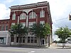 | July 6, 1989 (#89000803) | Roughly bounded by Sixth Ave., Sixth St., Ninth Ave., and Fourteenth St. 31°58′12″N 83°46′57″W / 31.97°N 83.7825°W / 31.97; -83.7825 (Cordele Commercial Historic District) | Cordele | Includes a 1907 Masonic Lodge designed in Beaux Arts style by architect T. Firth Lockwood, Sr. |
| 3 | Gillespie-Selden Historic District | Upload image | December 2, 1998 (#97000336) | Roughly bounded by Railroad, 10th, and 15th Sts., and 16th Ave. 31°57′55″N 83°47′27″W / 31.96523°N 83.79083°W / 31.96523; -83.79083 (Gillespie-Selden Historic District) | Cordele | African-American neighborhood, including the Gillespie-Selden Institute |
| 4 | O'Neal School Neighborhood Historic District | Upload image | October 6, 2004 (#04000339) | Roughly bounded by the Seaboard Coastline Railroad, Owens St. 16th Ave. and 6th St. 31°57′59″N 83°46′31″W / 31.966389°N 83.775278°W / 31.966389; -83.775278 (O'Neal School Neighborhood Historic District) | Cordele | |
| 5 | US Post Office-Cordele | 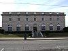 | June 29, 1984 (#84000977) | 102-104 6th St. 31°58′08″N 83°46′53″W / 31.96880°N 83.78135°W / 31.96880; -83.78135 (US Post Office-Cordele) | Cordele |
References
- ^ National Park Service, United States Department of the Interior, "National Register of Historic Places: Weekly List Actions", retrieved June 28, 2024.
- ^ Numbers represent an alphabetical ordering by significant words. Various colorings, defined here, differentiate National Historic Landmarks and historic districts from other NRHP buildings, structures, sites or objects.
- ^ The eight-digit number below each date is the number assigned to each location in the National Register Information System database, which can be viewed by clicking the number.
Wikimedia Commons has media related to National Register of Historic Places in Crisp County, Georgia.
| |
|---|---|
| Topics | |
| Lists by state |
|
| Lists by insular areas | |
| Lists by associated state | |
| Other areas | |
| Related | |
| |


