National Register of Historic Places listings in Polk County, Oregon

This list presents the full set of buildings, structures, objects, sites, or districts designated on the National Register of Historic Places in Polk County, Oregon, and offers brief descriptive information about each of them. The National Register recognizes places of national, state, or local historic significance across the United States.[1] Out of over 90,000 National Register sites nationwide,[2] Oregon is home to over 2,000,[3] and 34 of those are found in Polk County.
This National Park Service list is complete through NPS recent listings posted July 5, 2024.[4]
Current listings
| [5] | Name on the Register | Image | Date listed[6] | Location | City or town | Description |
|---|---|---|---|---|---|---|
| 1 | Beulah Methodist Episcopal Church |  | December 31, 2002 (#02001638) | 242 North Main 44°51′59″N 123°25′49″W / 44.866389°N 123.430278°W / 44.866389; -123.430278 (Beulah Methodist Episcopal Church) | Falls City | |
| 2 | Harrison Brunk House |  | May 6, 1975 (#75001599) | Brunks Corner and Oregon Route 22 44°56′01″N 123°08′48″W / 44.933611°N 123.146667°W / 44.933611; -123.146667 (Harrison Brunk House) | Brunks Corner | |
| 3 | Burford-Stanley House |  | February 24, 2022 (#100007458) | 342 Monmouth Ave. South 44°50′45″N 123°14′15″W / 44.8459°N 123.2375°W / 44.8459; -123.2375 (Burford-Stanley House) | Monmouth | |
| 4 | James S. and Jennie M. Cooper House |  | February 22, 1988 (#88000092) | 242 D Street[7] 44°51′01″N 123°11′12″W / 44.850414°N 123.186591°W / 44.850414; -123.186591 (James S. and Jennie M. Cooper House) | Independence | |
| 5 | Joseph and Priscilla Craven House |  | March 5, 1998 (#98000210) | 858 E. Main St. 44°50′56″N 123°13′30″W / 44.848889°N 123.225°W / 44.848889; -123.225 (Joseph and Priscilla Craven House) | Monmouth | |
| 6 | Dallas Cinema | 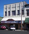 | October 28, 2022 (#100008328) | 166 SE Mill St. 44°55′18″N 123°18′57″W / 44.9216°N 123.3158°W / 44.9216; -123.3158 (Dallas Cinema) | Dallas | |
| 7 | Dallas Downtown Historic District |  | May 24, 2024 (#100010387) | Generally bounded by Washington, Church, Oak, and Jefferson streets. 44°55′17″N 123°19′00″W / 44.9215°N 123.3167°W / 44.9215; -123.3167 (Dallas Downtown Historic District) | Dallas | |
| 8 | Dallas Tannery |  | November 6, 1980 (#80003379) | 505 SW Levens St. 44°55′32″N 123°19′09″W / 44.925556°N 123.319167°W / 44.925556; -123.319167 (Dallas Tannery) | Dallas | |
| 9 | Dr. John E. and Mary D. Davidson House |  | February 28, 1985 (#85000371) | 887 Monmouth St. 44°51′03″N 123°11′46″W / 44.850879°N 123.196247°W / 44.850879; -123.196247 (Dr. John E. and Mary D. Davidson House) | Independence | |
| 10 | Walter J. Domes House |  | March 9, 1990 (#90000373) | 8240 Pacific Hwy. W. 45°03′14″N 123°12′24″W / 45.053942°N 123.206629°W / 45.053942; -123.206629 (Walter J. Domes House) | Rickreall | |
| 11 | Kersey C. Eldridge House |  | July 14, 1988 (#88001040) | 675 Monmouth St. 44°51′03″N 123°11′36″W / 44.850878°N 123.193227°W / 44.850878; -123.193227 (Kersey C. Eldridge House) | Independence | |
| 12 | Fort Yamhill Site | 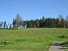 | July 27, 1971 (#71000681) | 32130–37008 3 Rivers Highway[8] 45°04′08″N 123°34′12″W / 45.068952°N 123.570056°W / 45.068952; -123.570056 (Fort Yamhill Site) | Grand Ronde[8] | |
| 13 | Grand Ronde Rail Depot |  | December 26, 2012 (#12001092) | 8615 Grand Ronde Road 45°03′36″N 123°36′39″W / 45.060016°N 123.610735°W / 45.060016; -123.610735 (Grand Ronde Rail Depot) | Grand Ronde | |
| 14 | Graves–Fisher–Strong House |  | June 20, 1985 (#85001336) | 391 E. Jackson St. 44°50′59″N 123°13′51″W / 44.849722°N 123.230833°W / 44.849722; -123.230833 (Graves–Fisher–Strong House) | Monmouth | |
| 15 | Jesse and Julia Harritt House |  | April 2, 1999 (#99000356) | 2280 Wallace Rd. NW 44°58′00″N 123°03′28″W / 44.966713°N 123.057718°W / 44.966713; -123.057718 (Jesse and Julia Harritt House) | Salem | |
| 16 | Sarah Helmick State Park |  | May 9, 2022 (#100007759) | 10485 Helmick Rd. 44°46′54″N 123°14′16″W / 44.7818°N 123.2379°W / 44.7818; -123.2379 (Sarah Helmick State Park) | Monmouth vicinity | |
| 17 | John W. Howell House |  | September 10, 1987 (#87001536) | 212 N. Knox St. 44°50′59″N 123°13′59″W / 44.849722°N 123.233056°W / 44.849722; -123.233056 (John W. Howell House) | Monmouth | |
| 18 | Independence Historic District | 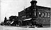 | March 1, 1989 (#89000048) | Roughly bounded by Butler, Main, G, and Ninth Sts. 44°51′02″N 123°11′23″W / 44.850556°N 123.189722°W / 44.850556; -123.189722 (Independence Historic District) | Independence | |
| 19 | Independence National Bank | 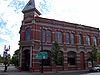 | November 6, 1986 (#86003182) | 302 S. Main St. 44°51′04″N 123°11′05″W / 44.851023°N 123.184837°W / 44.851023; -123.184837 (Independence National Bank) | Independence | |
| 20 | Parker School |  | June 16, 1989 (#89000514) | 8900 Parker Rd. 44°46′47″N 123°12′38″W / 44.779722°N 123.210556°W / 44.779722; -123.210556 (Parker School) | Independence | |
| 21 | John Phillips House |  | March 15, 1976 (#76001588) | Northwest of Salem on Spring Valley Rd. 45°01′40″N 123°07′29″W / 45.027778°N 123.124722°W / 45.027778; -123.124722 (John Phillips House) | Salem | |
| 22 | Polk County Bank |  | November 6, 1986 (#86003179) | 295 E. Main St. 44°50′54″N 123°13′55″W / 44.848333°N 123.231944°W / 44.848333; -123.231944 (Polk County Bank) | Monmouth | |
| 23 | Riley–Cutler House |  | April 3, 1980 (#80003380) | 11510 Pedee Creek Rd. 44°46′06″N 123°26′44″W / 44.768396°N 123.445507°W / 44.768396; -123.445507 (Riley–Cutler House) | Monmouth vicinity | |
| 24 | Ritner Creek Bridge |  | November 29, 1979 (#79002147) | South of Pedee 44°43′44″N 123°26′28″W / 44.728889°N 123.441111°W / 44.728889; -123.441111 (Ritner Creek Bridge) | Monmouth | |
| 25 | Saint Patrick's Roman Catholic Church |  | February 5, 1987 (#87000040) | 330 Monmouth St. 44°51′05″N 123°11′16″W / 44.851345°N 123.187841°W / 44.851345; -123.187841 (Saint Patrick's Roman Catholic Church) | Independence | |
| 26 | Edward W. St. Pierre House |  | February 21, 1989 (#89000050) | 2425 Eola Dr. 44°56′40″N 123°04′55″W / 44.944577°N 123.081946°W / 44.944577; -123.081946 (Edward W. St. Pierre House) | Salem | |
| 27 | Eleanor Sherman House |  | February 21, 1989 (#89000054) | 175 N. Craven St. 44°50′58″N 123°13′31″W / 44.849444°N 123.225278°W / 44.849444; -123.225278 (Eleanor Sherman House) | Monmouth | |
| 28 | Spring Valley Presbyterian Church |  | May 15, 1974 (#74001717) | Southeast of McCoy 45°00′46″N 123°07′43″W / 45.012745°N 123.128533°W / 45.012745; -123.128533 (Spring Valley Presbyterian Church) | Salem vicinity | |
| 29 | Spring Valley School |  | February 9, 2018 (#100002097) | 8295 Spring Valley Road NW 45°03′14″N 123°05′55″W / 45.053973°N 123.098711°W / 45.053973; -123.098711 (Spring Valley School) | Zena | |
| 30 | Union Street Railroad Bridge and Trestle |  | January 11, 2006 (#05001520) | Junction of Union and Water Streets, NE (See also Marion County.) 44°56′50″N 123°02′31″W / 44.94712°N 123.042°W / 44.94712; -123.042 (Union Street Railroad Bridge and Trestle) | Salem | |
| 31 | George A. Wells Jr. House |  | December 22, 1981 (#81000521) | 10635 Buena Vista Rd. 44°46′47″N 123°09′05″W / 44.779722°N 123.151389°W / 44.779722; -123.151389 (George A. Wells Jr. House) | Independence | |
| 32 | Old West Salem City Hall |  | June 1, 1990 (#90000841) | 1320 Edgewater St. NW 44°56′23″N 123°03′33″W / 44.939722°N 123.059167°W / 44.939722; -123.059167 (Old West Salem City Hall) | Salem | |
| 33 | J. A. Wheeler House |  | November 6, 1986 (#86003177) | 386 Monmouth St. 44°51′05″N 123°11′19″W / 44.851368°N 123.188693°W / 44.851368; -123.188693 (J. A. Wheeler House) | Independence | |
| 34 | A. K. Wilson Building |  | July 31, 1998 (#98000952) | 887 Main St. 44°55′14″N 123°19′01″W / 44.920690°N 123.317062°W / 44.920690; -123.317062 (A. K. Wilson Building) | Dallas |
Former listings
| [5] | Name on the Register | Image | Date listed | Date removed | Location | City or town | Description |
|---|---|---|---|---|---|---|---|
| 1 | Pumping Station Bridge |  | November 29, 1979 (#79002146) | May 18, 1987 | SW of Ellendale | Ellendale vicinity | Collapsed during a flood on November 24, 1986. |
See also
 Oregon portal
 National Register of Historic Places portal


- National Register of Historic Places listings in Oregon
- Listings in neighboring counties: Benton, Lincoln, Linn, Marion, Tillamook, Yamhill
- Historic preservation
- History of Oregon
- Lists of Oregon-related topics
References
- ^ Andrus, Patrick W.; Shrimpton, Rebecca H.; et al. (2002), How to Apply the National Register Criteria for Evaluation, National Register Bulletin, National Park Service, U.S. Department of the Interior, OCLC 39493977, archived from the original on April 6, 2014, retrieved June 20, 2014.
- ^ National Park Service, National Register of Historic Places Program: Research, archived from the original on February 1, 2015, retrieved January 28, 2015.
- ^ Oregon Parks and Recreation Department, Oregon Historic Sites Database, retrieved August 6, 2015. Note that a simple count of National Register records in this database returns a slightly higher total than actual listings, due to duplicate records. A close reading of detailed query results is necessary to arrive at the precise count.
- ^ National Park Service, United States Department of the Interior, "National Register of Historic Places: Weekly List Actions", retrieved July 5, 2024.
- ^ a b Numbers represent an alphabetical ordering by significant words. Various colorings, defined here, differentiate National Historic Landmarks and historic districts from other NRHP buildings, structures, sites or objects.
- ^ The eight-digit number below each date is the number assigned to each location in the National Register Information System database, which can be viewed by clicking the number.
- ^ Oneill, Therese (January 31, 2010), "Pink House Cafe offers big time elegance in a small town", WillametteLive.com (review), archived from the original on December 24, 2013, retrieved October 4, 2013.
- ^ a b Oregon Parks and Recreation Department, Fort Yamhill State Heritage Area, retrieved September 11, 2014.
External links
Map all coordinates using OpenStreetMap
Download coordinates as:
- KML
- GPX (all coordinates)
- GPX (primary coordinates)
- GPX (secondary coordinates)
- Oregon Parks and Recreation Department, National Register Program
- National Park Service, National Register of Historic Places site
 Media related to National Register of Historic Places in Polk County, Oregon at Wikimedia Commons
- v
- t
- e
by county

- National Historic Landmarks
- Bridges and Tunnels
- National Historic Sites
- National Monuments
| |
|---|---|
| Topics | |
| Lists by state |
|
| Lists by insular areas | |
| Lists by associated state | |
| Other areas | |
| Related | |
| |

Municipalities and communities of Polk County, Oregon, United States | ||
|---|---|---|
County seat: Dallas | ||
| Cities |  | |
| CDPs | ||
| Unincorporated communities | ||
| Indian reservation | ||
| Ghost towns | ||
| Footnotes | ‡This populated place also has portions in an adjacent county or counties | |
| ||


